Becker- Das Weingut
,


,


Becker - Das Weingut
Marco Becker
Römerstr. 1
55129 Mainz-Ebersheim

The little chapel naming the vineyard
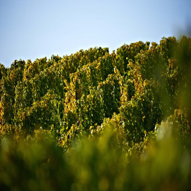
The name of the single vineyard comes from the small chapel on the outskirts of Ober-Olm, the St. Valentinus Chapel. It was mentioned as early as 1342. The present building is a late Gothic hall church that was extended around 1720 in Baroque style. The chapel was formerly the destination of pilgrimages to St. Valentine, the emergency helper of those suffering from the "falling sickness". A wide variety of grape varieties thrive on clay marl and limestone. The single vineyard sites are widely distributed: The largest area lies on the outskirts of Ober-Olm in the direction of Essenheim, smaller areas lie to the north-east in the direction of Klein-Winternheim and to the east towards Ebersheim.
> A circular route of the municipality of Ober-Olm, also to the chapel: https://www.ober-olm.de/punkt-9-kapelle
> Nearby: the Ober-Olper forest https://www.wald-rlp.de/de/forstamt-rheinhessen/wald/naturschutzgebiete-vor-den-toren-der-hauptstadt/vom-militaerstandort-zum/wald-mit-neuen-wegen/

Talk is silver, drinking is gold
Were there silver deposits in Rheinhessen or in the village of Mommenheim? Questionable. The location was already mentioned in a document in 1436 with the name "in der silbergruben". A pit is a depression in the ground, so far so good. After all, Mommenheim is located at the foot of the Zornheimer Berg. The "silver" in the name of vineyards is usually meant metaphorically. Just like the term "gold." It underlines the value of the site. Rarely is the naming based on really shiny minerals, like galena (also called galena among miners) or silver ore. If this were the case in the fertile loess soils in the Mommenheim silver mine, it would certainly be publicized. Already Charles the Great had a vineyard planted in Mommenheim. Possibly near today's friendship bench at the Wingertshäuschen?
> The Amiche bike tour (asphalted paths on a former railroad line) runs past Mommenheim: https://www.rheinhessen.de/amiche-radweg#dmdtab=oax-tab1
An old votive cross gave this location its name.

Standing out
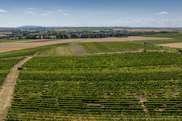
Framersheimer Hornberg, Ingelheimer Horn, Siefersheimer Goldenes Horn. The vineyard name with the suffix "Horn" is popular because it denotes protruding corners of a plateau. But there is ony thing that only Framersheim has: a 7-way labyrinth on the eastern tip of the Horn, built from 350 tonnes of limestone boulders. The curves there go back and forth, but never astray. At a height of about 280 metres, you can enjoy the view of the Odenwald (east), Kloppberg (south), Donnersberg (west) and Taunus with the Rhine plain (north). Clay marl forms the soil for numerous grape varieties.
> Discover the single vineyard by bike via Mühlen-Radweg.
Framersheim is the starting or end point.
https://www.rheinhessen.de/radrouten-rheinhessen/muehlen-radweg
> More information about the Labyrinth Square. It is freely accessible.
https://www.framersheim.de/fa/tourismus/labyrinth.php
> On the photos you can also see: the water house (fenced)
The location was mentioned in 1401 under the name "under the leyden hedges". The name derives from the Middle German word lite and means hillside.
In a metaphorical name, this is a good vineyard location. Only rarely is such a name based on the occurrence of shiny rocks such as galena.
The name refers to either a wine cellar, a potato and beet rental in the midst of vineyards or on old settlement remains.

Steep up to the crypt, steep site for Riesling vintners
A path to the Lord God? Yes! Or at least almost. A steep path winds its way from Gau-Odernheim up to the 246-metre-high Petersberg, on whose spire stood a three-nave basilica with crypt dating from the 10th century. The remains of the crypt, which were found from 1947 onwards, are impressive: this architecture is otherwise only found in central Italy, and for Rheinhessen it is unique. The single vineyard takes its name from the processions that have led to the top of the mountain on church feast days for centuries. Full-bodied Rieslings with a high aging potential thrive here on clay marl. The Petersberg cultural trail offers a variety of insights into history, geology, fauna and flora - and leads right through the middle of this single vineyard.
> Discover the Petersberg cultural trail with the wine table: https://kulturweg-petersberg.de/2014-10-26-16-54-02/foerderung-3/14-sample-data-articles/113-gau-odernheimer-herrgottspfad
> Go to the report "A summit tour in Rheinhessen" on the Rheinhessen blog: https://blog.rheinhessen.de/der-kulturweg-petersberg/
> A vineyard swing invites you to enjoy the panorama in the direction of the Rhine Valley and Kloppberg.
The location designation is based on a monastery property.


